


Descrizione di Handy GPS (free)
The perfect companion for your next outdoor adventure. Seek, find, record and return home with Handy GPS. No user account or setup required - just install it, turn on your GPS and go!
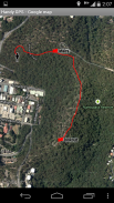
This app is a powerful navigation tool designed for outdoors sports like hiking, bushwalking, tramping, mountain biking, kayaking, horse trail riding, and geocaching. Its also useful for surveying, mining, archaeology, and forestry applications. Its simple to use and works even in the remotest back country since it doesn't require network connectivity. It allows you to work in UTM or lat/lon coordinates so you can even use it with your paper topographic maps. Waypoints and track logs recorded in the field can be be viewed later in Google Earth.
NOTE: This is a free trial version and is limited to storing only 3 waypoints, and 40 track log points. You can use the trial version for as long as you want, but if you like this app, please install the paid version of "Handy GPS" to get an unlimited version with lots more features. Thanks!
BASE FEATURES:
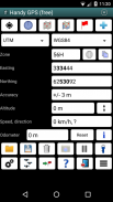
* Shows your current coordinates, altitude, speed, direction of travel, and total distance travelled in metric, imperial/US, or nautical units.
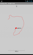
* Can store your current location as a waypoint, and record a track log to show where you've been on a map.
* Data can be imported from and exported to Google Earth KML and GPX files.
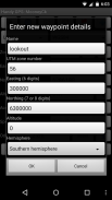
* Allows manual entry of waypoints in UTM, MGRS and lat/lon coords.
* Can guide you to a waypoint using the "Goto" screen, and optionally sound an alert when when you're getting close.
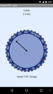
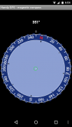
* Has a compass page which works on devices with magnetic field sensors.
* Automatically computes the local geoid offset to improve altitude accuracy
* Supports the world-wide WGS84 datum along with the common Australian datums and map grids. You can use WGS84 for NAD83 maps in the US.
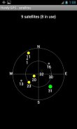
* Shows GPS satellite locations and signal strengths graphically.
* Can display simple or MGRS grid references.
* Can compute waypoint-to-waypoint distance and direction.
* Includes an optional timer line to record walk duration and compute your average speed.
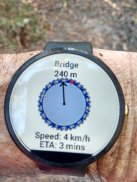
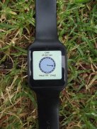
* If you have an Android Wear smartwatch, a stand-alone watch version of the app will also be installed. (The free Wear version is limited to storing 1 waypoint).
* Thoroughly tested by the developer on many off-track walks
EXTRA FEATURES ONLY IN THE PAID VERSION:
* No ads.
* An unlimited number of waypoints and track log points.
* Offline maps.
* Custom datums.
* Elevation profile.
* Take photos and record voice memos from the app.
* Email or SMS your location to a friend.
* UK grid refs.
* GPS averaging to improve location accuracy,
* Sun rise and set times.
* Export waypoints and tracklogs to a CSV file.
* Project waypoints using bearing and distance.
* Compute length, area, and elevation change from the tracklog.
* Compute calories.
PERMISSIONS: (1) GPS - to determine your location, (2) Network access - for access to Google Map and OSM tiles, (3) SD card access - to load and store waypoints and tracklogs, (4) Camera access for taking pics*, (5) Prevent phone from sleeping so that proximity alarm works, (6) Control flashlight, to allow the flashlight to be turned on/off from within the app, (7) System settings, to allow the Android Wear app to control the watch screen brightness, (8) Record audio for voice memos*. (* Feature only available in full version of app).
Disclaimer: You use this app at your own risk. The developer accepts no responsibility for you getting lost or injured as a result of using this app. Batteries in mobile devices can go flat. An alternate power source is recommended for extended hikes.
Versions of this app are also available for iPhones and Windows Phones.
Il compagno perfetto per la tua prossima avventura all'aria aperta. Cerca, trova, registra e torna a casa con Handy GPS. Nessun account utente o configurazione richiesta: basta installarlo, accendere il GPS e andare!
Questa applicazione è un potente strumento di navigazione progettato per gli sport all'aria aperta come trekking, passeggiate nel bush, calpestamento, mountain bike, kayak, equitazione e geocaching. È anche utile per indagini, miniere, archeologia e applicazioni forestali. È semplice da utilizzare e funziona anche nel paese più remoto perché non richiede la connettività di rete. Ti permette di lavorare in coordinate UTM o lat / lon in modo da poterlo usare anche con le tue carte topografiche cartacee. Waypoint e registri di traccia registrati nel campo possono essere visualizzati in seguito in Google Earth.
NOTA: Questa è una versione di prova gratuita ed è limitata alla memorizzazione di solo 3 waypoint e 40 punti del registro traccia. Puoi utilizzare la versione di prova per tutto il tempo che desideri, ma se ti piace questa app, installa la versione a pagamento di "Handy GPS" per ottenere una versione illimitata con molte altre funzionalità. Grazie!
CARATTERISTICHE BASE:
* Mostra le coordinate correnti, l'altitudine, la velocità, la direzione del viaggio e la distanza totale percorsa in unità metriche, imperiali / statunitensi o nautiche.
* Può memorizzare la posizione corrente come waypoint e registrare un registro traccia per mostrare dove sei stato su una mappa.
* I dati possono essere importati ed esportati nei file KML e GPX di Google Earth.
* Permette l'inserimento manuale dei waypoint in UTM, MGRS e lat / lon coords.
* Può guidarti verso un waypoint usando la schermata "Goto" e, facoltativamente, emettere un avviso quando ti stai avvicinando.
* Ha una pagina della bussola che funziona su dispositivi con sensori di campo magnetico.
* Calcola automaticamente l'offset del geoide locale per migliorare la precisione dell'altitudine
* Supporta il dato mondiale WGS84 insieme ai comuni datum australiani e alle griglie delle mappe. È possibile utilizzare WGS84 per le mappe NAD83 negli Stati Uniti.
* Mostra graficamente le posizioni satellitari GPS e l'intensità del segnale.
* Può visualizzare riferimenti a griglia semplici o MGRS.
* Può calcolare distanza e direzione waypoint-to-waypoint.
* Include una linea timer opzionale per registrare la durata della camminata e calcolare la velocità media.
* Se si dispone di uno smartwatch Android Wear, verrà installata anche una versione indipendente dell'orologio. (La versione Wear gratuita è limitata alla memorizzazione di 1 waypoint).
* Completamente testato dallo sviluppatore in molte passeggiate fuori pista
ULTERIORI CARATTERISTICHE SOLO NELLA VERSIONE PAGATA:
* Nessuna pubblicità.
* Un numero illimitato di waypoint e punti del registro di traccia.
* Mappe offline.
* Riferimenti personalizzati.
* Profilo altimetrico.
* Scatta foto e registra memo vocali dall'app.
* Invia per email o SMS la tua posizione a un amico.
* Rifiuti della griglia del Regno Unito.
* Medie GPS per migliorare la precisione della posizione,
* Sole sorgere e impostare i tempi.
* Esportare waypoint e tracklog in un file CSV.
* Proietta i waypoint usando il rilevamento e la distanza.
* Calcola lunghezza, area e cambio di quota dal tracklog.
* Calcola calorie.
AUTORIZZAZIONI: (1) GPS - per determinare la posizione, (2) Accesso alla rete - per accedere ai riquadri Google Map e OSM, (3) Accesso alla scheda SD - per caricare e memorizzare waypoint e tracklist, (4) Accesso alla fotocamera per scattare foto *, (5) Impedisce al telefono di dormire in modo che l'allarme di prossimità funzioni, (6) Controlla la torcia elettrica, per consentire l'accensione / spegnimento della torcia dall'interno dell'app, (7) Impostazioni di sistema, per consentire all'app Android Wear di controllare la luminosità dello schermo dell'orologio, (8) Registra l'audio per i memo vocali *. (* Funzionalità disponibile solo nella versione completa dell'app).
Dichiarazione di non responsabilità: si utilizza questa app a proprio rischio. Lo sviluppatore non si assume alcuna responsabilità in caso di smarrimento o infortunio a seguito dell'utilizzo di questa app. Le batterie nei dispositivi mobili possono diventare piatte. Una fonte di energia alternativa è raccomandata per escursioni prolungate.
Le versioni di questa app sono disponibili anche per iPhone e telefoni Windows.
Handy GPS (free) - Versione 41.3
(15-09-2023)
Handy GPS (free) - Informazioni APK
Versione APK: 41.3Pacchetto: binaryearth.handygpsfreeApp nella stessa categoria
Potrebbe piacerti anche...


